
Thank you for supporting this site ❤️
Make a donation
Make a donation
Gear up for your next adventure:
As an Amazon Associate, this site earns from qualifying purchases at no extra cost to you.
Heide topographic map
Click on the map to display elevation.
Thank you for supporting this site ❤️
Make a donation
Make a donation
Gear up for your next adventure:
As an Amazon Associate, this site earns from qualifying purchases at no extra cost to you.
About this map
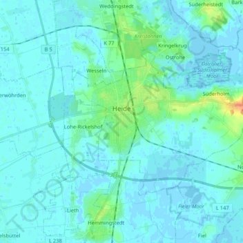
Name: Heide topographic map, elevation, terrain.
Location: Heide, Kreis Dithmarschen, Schleswig-Holstein, 25746, Germany (54.16103 9.05261 54.21828 9.21301)
Average elevation: 16 ft
Minimum elevation: -10 ft
Maximum elevation: 115 ft
Thank you for supporting this site ❤️
Make a donation
Make a donation
Gear up for your next adventure:
As an Amazon Associate, this site earns from qualifying purchases at no extra cost to you.
Other topographic maps
Click on a map to view its topography, its elevation and its terrain.
Alter Meldorfer Hafen
Germany > Schleswig-Holstein > Kreis Dithmarschen > Meldorf
Average elevation: 7 ft