Geolocate

Poxstall topographic map

Click on the map to display elevation.

Poxstall

Das in der Wiesentalb gelegene Dorf liegt etwa dreieinhalb Kilometer westsüdwestlich des Ortszentrums von Ebermannstadt auf einer Höhe von 392 m ü. NHN.

Wikipedia (CC-BY-SA 3.0)

About this map

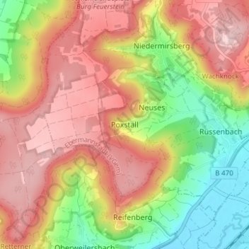
Name: Poxstall topographic map, elevation, terrain.

Location: Poxstall, Ebermannstadt, Ebermannstadt (VGem), Landkreis Forchheim, Bayern, 91365, Deutschland (49.75186 11.11720 49.79186 11.15720)

Average elevation: 1,368 ft

Minimum elevation: 925 ft

Maximum elevation: 1,739 ft

Other topographic maps

Click on a map to view its topography, its elevation and its terrain.

Gear up for your next adventure:

📱Heavy-Duty Phone Cases - Drop-proof and waterproof protection for outdoor navigation
🦺Reflective Outdoor Gear - Safety gear for low‑light conditions
🚁Photography Drones - Capture stunning aerial views of landforms and topography
Solar GPS Watches - Advanced multisport watches with built-in topographic maps
📱Solar Portable Charger - Solar power bank for charging devices off‑grid

As an Amazon Associate, this site earns from qualifying purchases at no extra cost to you.