
Make a donation
Gear up for your next adventure:
As an Amazon Associate, this site earns from qualifying purchases at no extra cost to you.
Großziegenfeld topographic map
Click on the map to display elevation.
Make a donation
Gear up for your next adventure:
As an Amazon Associate, this site earns from qualifying purchases at no extra cost to you.
Großziegenfeld
Zwischen 1996 und 1999 wurde die Kanalisation in Großziegenfeld ausgebaut und erneuert. Im Zuge dieser Baumaßnahmen wurden auch die Ortsdurchfahrt und der Dorfplatz erweitert und verschönert und erhielten ihr heutiges Aussehen. Am Dorfplatz wurde ein Kinderspielplatz eingerichtet und am Dorfrand ein Bolzplatz gebaut. Von 1999 bis 2000 wurde zum Kreisgartentag die Kirche innen und außen renoviert und mit Schiefer neu eingedeckt. Die Kosten in Höhe von 150.000 DM (~ 93.000 €) wurden fast ohne jegliche Zuschüsse von den Dorfbewohnern aufgebracht. Im Frühjahr 2000 fand der Kreisgartentag in Großziegenfeld statt, zu dem rund 15.000 Besucher kamen.
Make a donation
Gear up for your next adventure:
As an Amazon Associate, this site earns from qualifying purchases at no extra cost to you.
About this map
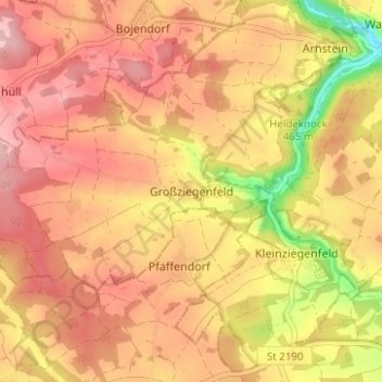
Name: Großziegenfeld topographic map, elevation, terrain.
Average elevation: 1,558 ft
Minimum elevation: 1,227 ft
Maximum elevation: 1,736 ft
Make a donation
Gear up for your next adventure:
As an Amazon Associate, this site earns from qualifying purchases at no extra cost to you.