
Thank you for supporting this site ❤️
Make a donation
Make a donation
Gear up for your next adventure:
As an Amazon Associate, this site earns from qualifying purchases at no extra cost to you.
Langenlois topographic map
Click on the map to display elevation.
Thank you for supporting this site ❤️
Make a donation
Make a donation
Gear up for your next adventure:
As an Amazon Associate, this site earns from qualifying purchases at no extra cost to you.
About this map
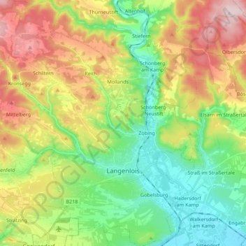
Name: Langenlois topographic map, elevation, terrain.
Location: Langenlois, Bezirk Krems, Basse-Autriche, 3550, Autriche (48.43828 15.56142 48.54987 15.72473)
Average elevation: 1,066 ft
Minimum elevation: 630 ft
Maximum elevation: 1,755 ft
Thank you for supporting this site ❤️
Make a donation
Make a donation
Gear up for your next adventure:
As an Amazon Associate, this site earns from qualifying purchases at no extra cost to you.
Other topographic maps
Click on a map to view its topography, its elevation and its terrain.
Klein-Wien
Autriche > Basse-Autriche > Bezirk Krems > Gemeinde Furth bei Göttweig
Average elevation: 1,010 ft