
Make a donation
Gear up for your next adventure:
As an Amazon Associate, this site earns from qualifying purchases at no extra cost to you.
Timergara topographic map
Click on the map to display elevation.
Make a donation
Gear up for your next adventure:
As an Amazon Associate, this site earns from qualifying purchases at no extra cost to you.
Timergara
Timergara (Pashto: تيمرګره, Urdu: تیمرگرہ) is a city and the district headquarters of the Lower Dir District and temporary headquarter of newly established Central Dir District in Khyber Pakhtunkhwa, Pakistan. Timergara city is located on the east bank of the Panjkora River. It lies at an altitude of 823 metres (2,700 ft). The town is the site of excavated graves of Indo-Aryans, dating from 1500 to 600 BC. On the west side of the Panjkora River is the excavated site of Balambat. The site has been occupied continuously since the time of the Indo-Aryans in 1500 BC. Discoveries included houses dating from 500 BC and fire altars, showing that the people followed early Vedic Hinduism which revolved around fire worshipping. The areas early political history is defined by the control of the Hindu Shahis, artifacts and ruins from the period is found throughout the region. At the 2023 Census, the town had a population of 47,860. Most of the main city lies on the bank of the river Panjkora, which separates Balambat from the main city.
Make a donation
Gear up for your next adventure:
As an Amazon Associate, this site earns from qualifying purchases at no extra cost to you.
About this map
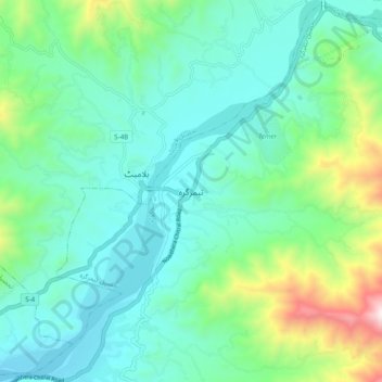
Name: Timergara topographic map, elevation, terrain.
Average elevation: 3,025 ft
Minimum elevation: 2,241 ft
Maximum elevation: 5,778 ft
Make a donation
Gear up for your next adventure:
As an Amazon Associate, this site earns from qualifying purchases at no extra cost to you.