Geolocate

Yapton topographic map

Click on the map to display elevation.

About this map

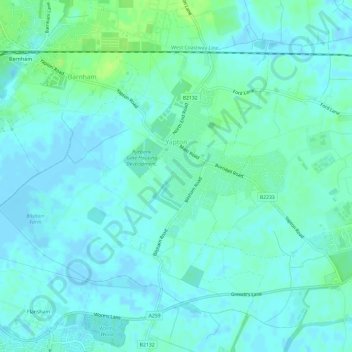
Name: Yapton topographic map, elevation, terrain.

Location: Yapton, Arun, West Sussex, England, United Kingdom (50.79992 -0.65568 50.83517 -0.59618)

Average elevation: 13 ft

Minimum elevation: -13 ft

Maximum elevation: 39 ft

Other topographic maps

Click on a map to view its topography, its elevation and its terrain.

Harrow Hill

United Kingdom > England > West Sussex > Arun

Average elevation: 348 ft

Felpham

United Kingdom > England > West Sussex > Arun > Felpham

Average elevation: 7 ft

Gear up for your next adventure:

🪑Portable Camp Table - Compact table for campsite meals
🔊Portable Camp Speaker - Music and alerts at camp
🔦Compact Flashlight - Reliable flashlight for emergencies
🔋Rechargeable Batteries - Power up your outdoor devices
Backpacking Tents - Weight-optimized shelters for multi-day topographic surveys

As an Amazon Associate, this site earns from qualifying purchases at no extra cost to you.