
Make a donation
Gear up for your next adventure:
As an Amazon Associate, this site earns from qualifying purchases at no extra cost to you.
Santo Afonso topographic map
Click on the map to display elevation.
Make a donation
Gear up for your next adventure:
As an Amazon Associate, this site earns from qualifying purchases at no extra cost to you.
Santo Afonso
Santo Afonso é um município brasileiro do estado de Mato Grosso localizado na latitude sul 14º29'51", longitude oeste 57º00'07", altitude de 400 metros acima do nível do mar. Em 2016, sua população era estimada em 3.044 habitantes. A área do município é de 1.172,87 km².
Make a donation
Gear up for your next adventure:
As an Amazon Associate, this site earns from qualifying purchases at no extra cost to you.
About this map
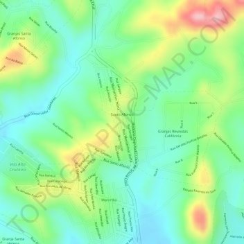
Name: Santo Afonso topographic map, elevation, terrain.
Average elevation: 2,690 ft
Minimum elevation: 2,493 ft
Maximum elevation: 3,025 ft
Make a donation
Gear up for your next adventure:
As an Amazon Associate, this site earns from qualifying purchases at no extra cost to you.
Other topographic maps
Click on a map to view its topography, its elevation and its terrain.
Parque Fernão Dias
Brasil > Minas Gerais > Região Metropolitana de Belo Horizonte > Betim
Average elevation: 3,084 ft
Comnidades
Brasil > Minas Gerais > Região Metropolitana de Belo Horizonte > Betim
Average elevation: 2,697 ft
Parque de Exposições David Gonçalves Lara
Brasil > Minas Gerais > Região Metropolitana de Belo Horizonte > Betim
Average elevation: 2,707 ft
Praça do Encontro Joaquim Ribeiro de Rezende
Brasil > Minas Gerais > Região Metropolitana de Belo Horizonte > Betim
Average elevation: 2,713 ft
Make a donation
Gear up for your next adventure:
As an Amazon Associate, this site earns from qualifying purchases at no extra cost to you.
Betim
Brasil > Minas Gerais > Região Metropolitana de Belo Horizonte > Betim
Average elevation: 2,812 ft
Praça Milton Campos
Brasil > Minas Gerais > Região Metropolitana de Belo Horizonte > Betim
Average elevation: 2,703 ft