
Make a donation
Gear up for your next adventure:
As an Amazon Associate, this site earns from qualifying purchases at no extra cost to you.
Rancho Grande topographic map
Click on the map to display elevation.
Make a donation
Gear up for your next adventure:
As an Amazon Associate, this site earns from qualifying purchases at no extra cost to you.
About this map
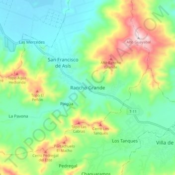
Name: Rancho Grande topographic map, elevation, terrain.
Average elevation: 1,952 ft
Minimum elevation: 1,414 ft
Maximum elevation: 3,130 ft
Make a donation
Gear up for your next adventure:
As an Amazon Associate, this site earns from qualifying purchases at no extra cost to you.
Other topographic maps
Click on a map to view its topography, its elevation and its terrain.
Río Guárico
Venezuela > Estado Aragua > Municipio Zamora > San Juan de Los Morros
Average elevation: 1,476 ft
Plaza Bolívar
Venezuela > Estado Aragua > Municipio Zamora > Villa de Cura
Average elevation: 1,821 ft
Make a donation
Gear up for your next adventure:
As an Amazon Associate, this site earns from qualifying purchases at no extra cost to you.