
Geismar topographic map
Click on the map to display elevation.
Geismar
Geismar is an unincorporated community in Ascension Parish, Louisiana, United States and is at the heart of Louisiana's chemical corridor. The community is part of the Baton Rouge metropolitan statistical area. Geismar is south of Prairieville and west of Gonzales. The community has Three schools, Dutchtown Primary School, Dutchtown Middle School and Dutchtown High School, which are ranked among the top schools in the state of Louisiana. The Mississippi River flows to the southeast along the southwest side of the community. The area is vulnerable to hurricanes and tropical systems due to its low elevation and its proximity to the coast of southeast Louisiana.
About this map
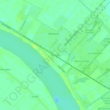
Name: Geismar topographic map, elevation, terrain.
Location: Geismar, Ascension Parish, Louisiana, United States (30.18436 -91.04260 30.22436 -91.00260)
Average elevation: 23 ft
Minimum elevation: -3 ft
Maximum elevation: 56 ft
Ascension Parish trails, hiking, mountain biking, running and outdoor activities
Other topographic maps
Click on a map to view its topography, its elevation and its terrain.