
Make a donation
Gear up for your next adventure:
As an Amazon Associate, this site earns from qualifying purchases at no extra cost to you.
Piesendorf topographic map
Click on the map to display elevation.
Make a donation
Gear up for your next adventure:
As an Amazon Associate, this site earns from qualifying purchases at no extra cost to you.
About this map
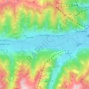
Name: Piesendorf topographic map, elevation, terrain.
Location: Piesendorf, Bezirk Zell am See, Salzbourg, 5721, Autriche (47.22991 12.66389 47.33252 12.77422)
Average elevation: 4,193 ft
Minimum elevation: 2,454 ft
Maximum elevation: 8,156 ft
Make a donation
Gear up for your next adventure:
As an Amazon Associate, this site earns from qualifying purchases at no extra cost to you.
Other topographic maps
Click on a map to view its topography, its elevation and its terrain.
Hinterglemm
Autriche > Salzbourg > Bezirk Zell am See > Saalbach-Hinterglemm
Average elevation: 4,567 ft
Make a donation
Gear up for your next adventure:
As an Amazon Associate, this site earns from qualifying purchases at no extra cost to you.
Sandebentörl
Autriche > Salzbourg > Bezirk Zell am See > Hollersbach im Pinzgau
Average elevation: 8,232 ft
Make a donation
Gear up for your next adventure:
As an Amazon Associate, this site earns from qualifying purchases at no extra cost to you.
Saalbach
Autriche > Salzbourg > Bezirk Zell am See > Saalbach-Hinterglemm > Saalbach
Average elevation: 4,331 ft
Ferleiten
Autriche > Salzbourg > Bezirk Zell am See > Fusch an der Großglocknerstraße > Ferleiten
Average elevation: 5,610 ft
Make a donation
Gear up for your next adventure:
As an Amazon Associate, this site earns from qualifying purchases at no extra cost to you.