
Thank you for supporting this site ❤️
Make a donation
Make a donation
Gear up for your next adventure:
As an Amazon Associate, this site earns from qualifying purchases at no extra cost to you.
Munyaka topographic map
Click on the map to display elevation.
Thank you for supporting this site ❤️
Make a donation
Make a donation
Gear up for your next adventure:
As an Amazon Associate, this site earns from qualifying purchases at no extra cost to you.
About this map
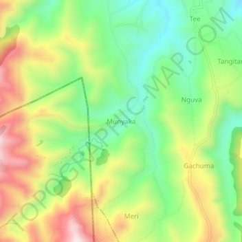
Name: Munyaka topographic map, elevation, terrain.
Location: Munyaka, Elementeita ward, Gilgil, Nakuru, Kenya (-0.66739 36.08405 -0.62739 36.12405)
Average elevation: 7,687 ft
Minimum elevation: 6,946 ft
Maximum elevation: 8,711 ft
Thank you for supporting this site ❤️
Make a donation
Make a donation
Gear up for your next adventure:
As an Amazon Associate, this site earns from qualifying purchases at no extra cost to you.