
Make a donation
Gear up for your next adventure:
As an Amazon Associate, this site earns from qualifying purchases at no extra cost to you.
Egebjerg topographic map
Click on the map to display elevation.
Make a donation
Gear up for your next adventure:
As an Amazon Associate, this site earns from qualifying purchases at no extra cost to you.
About this map
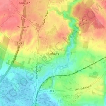
Name: Egebjerg topographic map, elevation, terrain.
Location: Egebjerg, Horsens Kommune, Region Midtjylland, 8751, Danmark (55.88312 9.81993 55.92312 9.85993)
Average elevation: 115 ft
Minimum elevation: -10 ft
Maximum elevation: 243 ft
Make a donation
Gear up for your next adventure:
As an Amazon Associate, this site earns from qualifying purchases at no extra cost to you.
Other topographic maps
Click on a map to view its topography, its elevation and its terrain.
Make a donation
Gear up for your next adventure:
As an Amazon Associate, this site earns from qualifying purchases at no extra cost to you.
Samsø
Der er spor fra mennesker på Samsø siden de tidligste tider, efter isen trak sig tilbage. Her jagtede man vildtet og siden bosatte man sig og begravede sine døde i gravhøje og rejste stendysser i stenalderen. Mange af gravhøjene på øen er dog fra bronzealderen, da man i denne periode anlagde dem på…
Average elevation: 7 ft
Make a donation
Gear up for your next adventure:
As an Amazon Associate, this site earns from qualifying purchases at no extra cost to you.
Make a donation
Gear up for your next adventure:
As an Amazon Associate, this site earns from qualifying purchases at no extra cost to you.
Make a donation
Gear up for your next adventure:
As an Amazon Associate, this site earns from qualifying purchases at no extra cost to you.
Make a donation
Gear up for your next adventure:
As an Amazon Associate, this site earns from qualifying purchases at no extra cost to you.
Nationalpark Mols Bjerge
Midt i nationalparken ligger den fredede del af Mols Bjerge, med bakker der når op i 137 meters højde, hvor der er udsigter over bl.a. Aarhusbugten, Ebeltoft Vig, Rønde, Aarhus og det sydlige Djursland. Mols Bjerge er forbundet med andre naturområder mod nord ved Femmøller, og omkring Lyngsbækgård og…
Average elevation: 52 ft
Make a donation
Gear up for your next adventure:
As an Amazon Associate, this site earns from qualifying purchases at no extra cost to you.
Make a donation
Gear up for your next adventure:
As an Amazon Associate, this site earns from qualifying purchases at no extra cost to you.
Make a donation
Gear up for your next adventure:
As an Amazon Associate, this site earns from qualifying purchases at no extra cost to you.
Anholt
Fyret er beliggende på Anholts nordøstlige spids ved næsset, der hedder Totten. Næsset strækker sig som et undersøisk rev flere kilometer ud i Kattegat til fare for skibsfarten. Her er der sket utallige strandinger gennem tiderne., så der var brug for et fyrtårn. Anholt Fyr er Danmarks ældste…
Average elevation: 7 ft
Make a donation
Gear up for your next adventure:
As an Amazon Associate, this site earns from qualifying purchases at no extra cost to you.
Skjern Å
Åen udspringer på den jyske højderyg omkring 24 kilometer nordnordvest for Vejle og 6 kilometer syd for Nørre Snede i en dalsænkning (68 meter over havet). Det er omtrent samme sted, som Gudenåens har sine kilder. Der er kun lidt over 100 meters afstand mellem de to. Åen løber mod nordnordvest, gennem…
Average elevation: 151 ft
Make a donation
Gear up for your next adventure:
As an Amazon Associate, this site earns from qualifying purchases at no extra cost to you.
Make a donation
Gear up for your next adventure:
As an Amazon Associate, this site earns from qualifying purchases at no extra cost to you.
Make a donation
Gear up for your next adventure:
As an Amazon Associate, this site earns from qualifying purchases at no extra cost to you.
Bølling Sø
I august 2004 blev afvandingskanalen dækket til og i løbet af blot et halvt år nåede vandoverfladen op til den planlagte højde, som er 67,25 meter over havets overflade.
Average elevation: 249 ft
Make a donation
Gear up for your next adventure:
As an Amazon Associate, this site earns from qualifying purchases at no extra cost to you.
Hald Sø
Danmark > Region Midtjylland > Birgittelyst
Da gletsjere fra Norge og Østersøegnene mødtes under sidste istid, blev det meget kuperede terræn ved Hald sø udformet. Hele den sydlige og østlige side af søen er omkranset af dybe skrænter, og det er ikke kun på søens bund at der er store højdeforskelle. Ved Skelhøje lige syd for søen når…
Average elevation: 112 ft
Make a donation
Gear up for your next adventure:
As an Amazon Associate, this site earns from qualifying purchases at no extra cost to you.
Make a donation
Gear up for your next adventure:
As an Amazon Associate, this site earns from qualifying purchases at no extra cost to you.
Make a donation
Gear up for your next adventure:
As an Amazon Associate, this site earns from qualifying purchases at no extra cost to you.
Make a donation
Gear up for your next adventure:
As an Amazon Associate, this site earns from qualifying purchases at no extra cost to you.