Geolocate

Aroumd topographic map

Click on the map to display elevation.

About this map

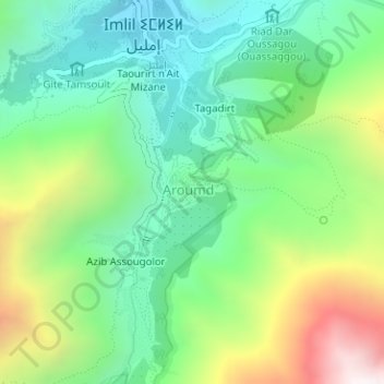
Name: Aroumd topographic map, elevation, terrain.

Location: Aroumd, Asni, Caïdat d'Asni, Cercle d'Asni, Al Haouz Province, Marrakech-Safi, Morocco (31.12304 -7.92031 31.12835 -7.91399)

Average elevation: 6,900 ft

Minimum elevation: 5,564 ft

Maximum elevation: 9,587 ft

Other topographic maps

Click on a map to view its topography, its elevation and its terrain.

Toubkal

Morocco > cercle d'Asni > Asni

Toubkal (Arabic: توبقال, romanized: tūbqāl, pronounced [tuːbqaːl]), also Jbel Toubkal or Jebel Toubkal, is a mountain in southwestern Morocco, located in the Toubkal National Park. At 4,167 m (13,671 ft), it is the highest peak in Morocco, the Atlas Mountains, North Africa and the Arab world. Located…

Average elevation: 11,864 ft

Tamadout

Morocco > cercle d'Asni > Asni > Tansghart

Average elevation: 4,833 ft

Tacheddirt

Morocco > cercle d'Asni > Asni

Average elevation: 8,907 ft

Tinerhourhine

Morocco > cercle d'Asni > Asni

Average elevation: 7,405 ft

Gear up for your next adventure:

🔌USB Car Charger - Car charger for on‑the‑go power needs
🚁Photography Drones - Capture stunning aerial views of landforms and topography
🛶Inflatable Kayak - Portable kayak for rivers, lakes, and expeditions
🪶Fire Starter Kit - Reliable fire starter for survival and camping
🗺️NatGeo Topo Maps - High-quality waterproof printed topographic maps of US Parks

As an Amazon Associate, this site earns from qualifying purchases at no extra cost to you.