
Make a donation
Gear up for your next adventure:
As an Amazon Associate, this site earns from qualifying purchases at no extra cost to you.
Pizzo Roseg topographic map
Click on the map to display elevation.
Make a donation
Gear up for your next adventure:
As an Amazon Associate, this site earns from qualifying purchases at no extra cost to you.
Pizzo Roseg
Le piz Roseg (prononcé pits rozétch) est un sommet des Alpes, à 3 935 m d'altitude, dans la chaîne de la Bernina, situé en Suisse dans le canton des Grisons. La frontière avec l'Italie passe non loin au sud, au sommet du Roseg Pitschen (3 867 m).
Make a donation
Gear up for your next adventure:
As an Amazon Associate, this site earns from qualifying purchases at no extra cost to you.
About this map
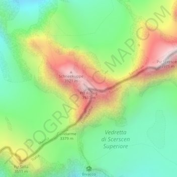
Name: Pizzo Roseg topographic map, elevation, terrain.
Location: Pizzo Roseg, Samedan, Maloja, Grisons, 7503, Suisse (46.37356 9.88323 46.37366 9.88333)
Average elevation: 10,771 ft
Minimum elevation: 9,386 ft
Maximum elevation: 12,966 ft
Make a donation
Gear up for your next adventure:
As an Amazon Associate, this site earns from qualifying purchases at no extra cost to you.