
Make a donation
Gear up for your next adventure:
As an Amazon Associate, this site earns from qualifying purchases at no extra cost to you.
Isla de Culebra topographic map
Click on the map to display elevation.
Make a donation
Gear up for your next adventure:
As an Amazon Associate, this site earns from qualifying purchases at no extra cost to you.
Isla de Culebra
Culebra is characterized by an irregular topography resulting in a long intricate shoreline. The island is approximately 7 by 5 miles (11 by 8 km). The coast is marked by cliffs, sandy coral beaches and mangrove forests. Inland, the tallest point on the island is Mount Resaca, with an elevation of 636 feet (193.9 meters), followed by Balcón Hill, with an elevation of 545 feet (166.1 meters).
Make a donation
Gear up for your next adventure:
As an Amazon Associate, this site earns from qualifying purchases at no extra cost to you.
About this map
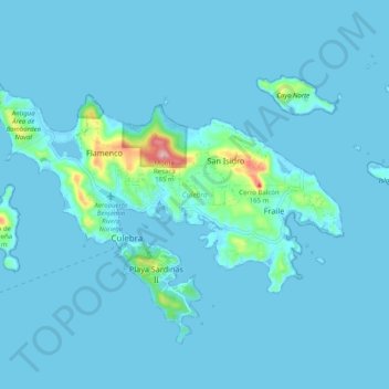
Name: Isla de Culebra topographic map, elevation, terrain.
Average elevation: 36 ft
Minimum elevation: -10 ft
Maximum elevation: 617 ft
Culebra trails, hiking, mountain biking, running and outdoor activities
Make a donation
Gear up for your next adventure:
As an Amazon Associate, this site earns from qualifying purchases at no extra cost to you.