Geolocate

Straw topographic map

Click on the map to display elevation.

About this map

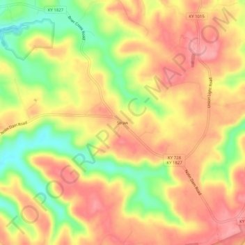
Name: Straw topographic map, elevation, terrain.

Location: Straw, Edmonson County, Kentucky, 42259, United States (37.25588 -86.19247 37.29588 -86.15247)

Average elevation: 738 ft

Minimum elevation: 512 ft

Maximum elevation: 892 ft

Edmonson County trails, hiking, mountain biking, running and outdoor activities

Gear up for your next adventure:

🧭Outdoor Navigation Book - Learn advanced navigation skills
🧭GPS Watch Accessories - Bands and chargers for GPS watches
📌Outdoor GPS Map App - Apps and devices for digital topographic navigation
📶Satellite Messenger - Communication device off‑grid
🛰️Handheld GPS Units - Professional satellite navigators for precise backcountry mapping

As an Amazon Associate, this site earns from qualifying purchases at no extra cost to you.