
Thank you for supporting this site ❤️
Make a donation
Make a donation
Gear up for your next adventure:
As an Amazon Associate, this site earns from qualifying purchases at no extra cost to you.
Xalpa topographic map
Click on the map to display elevation.
Thank you for supporting this site ❤️
Make a donation
Make a donation
Gear up for your next adventure:
As an Amazon Associate, this site earns from qualifying purchases at no extra cost to you.
About this map
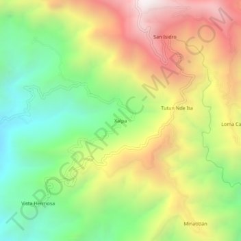
Name: Xalpa topographic map, elevation, terrain.
Location: Xalpa, Cochoapa el Grande, Guerrero, México (17.06278 -98.38333 17.10278 -98.34333)
Average elevation: 5,236 ft
Minimum elevation: 3,150 ft
Maximum elevation: 7,812 ft
Thank you for supporting this site ❤️
Make a donation
Make a donation
Gear up for your next adventure:
As an Amazon Associate, this site earns from qualifying purchases at no extra cost to you.