
Make a donation
Gear up for your next adventure:
As an Amazon Associate, this site earns from qualifying purchases at no extra cost to you.
Tall Hamu topographic map
Click on the map to display elevation.
Make a donation
Gear up for your next adventure:
As an Amazon Associate, this site earns from qualifying purchases at no extra cost to you.
About this map
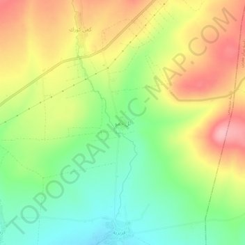
Name: Tall Hamu topographic map, elevation, terrain.
Location: Tall Hamu, Jendairis Subdistrict, Afrin District, Syria (36.39740 36.75179 36.43740 36.79179)
Average elevation: 827 ft
Minimum elevation: 614 ft
Maximum elevation: 1,073 ft
Make a donation
Gear up for your next adventure:
As an Amazon Associate, this site earns from qualifying purchases at no extra cost to you.
Other topographic maps
Click on a map to view its topography, its elevation and its terrain.
Barada River
Syria > Damascus Governorate > Damascus Subdistrict > Al-Qanawat Municipality
Average elevation: 2,306 ft
Make a donation
Gear up for your next adventure:
As an Amazon Associate, this site earns from qualifying purchases at no extra cost to you.
Euphrates
Both the Kara Su and the Murat Su rise northwest from Lake Van at elevations of 3,290 metres (10,790 ft) and 3,520 metres (11,550 ft) amsl, respectively. At the location of the Keban Dam, the two rivers, now combined into the Euphrates, have dropped to an elevation of 693 metres (2,274 ft) amsl. From Keban to…
Average elevation: 2,602 ft
Deir ez-Zor
Syria > Deir ez-Zor Governorate
From 10 April 2016 to 31 August 2017, the World Food Programme supplied the city with food and essential relief items through a high-altitude airdrop service. With a Russian contracted Il-76 aircraft and parachute systems provided by Canada, the US, and Russia, a total of 8015 pallets with an average weight of…
Average elevation: 702 ft
Make a donation
Gear up for your next adventure:
As an Amazon Associate, this site earns from qualifying purchases at no extra cost to you.
Make a donation
Gear up for your next adventure:
As an Amazon Associate, this site earns from qualifying purchases at no extra cost to you.
Tishreen Park
Syria > Damascus Governorate > Damascus Subdistrict > Al-Muhajerin Municipality
Average elevation: 2,530 ft
Make a donation
Gear up for your next adventure:
As an Amazon Associate, this site earns from qualifying purchases at no extra cost to you.
Al-Qaboun Municipality
Syria > Damascus Governorate > Damascus Subdistrict
Average elevation: 2,372 ft
Make a donation
Gear up for your next adventure:
As an Amazon Associate, this site earns from qualifying purchases at no extra cost to you.
Masakin Barza Neighborhood
Syria > Damascus Governorate > Damascus Subdistrict > Barza Municipality > Barzeh
Average elevation: 2,451 ft
Make a donation
Gear up for your next adventure:
As an Amazon Associate, this site earns from qualifying purchases at no extra cost to you.
Make a donation
Gear up for your next adventure:
As an Amazon Associate, this site earns from qualifying purchases at no extra cost to you.
Euphrates
Both the Kara Su and the Murat Su rise northwest from Lake Van at elevations of 3,290 metres (10,790 ft) and 3,520 metres (11,550 ft) amsl, respectively. At the location of the Keban Dam, the two rivers, now combined into the Euphrates, have dropped to an elevation of 693 metres (2,274 ft) amsl. From Keban to…
Average elevation: 2,602 ft
Al-Muhajerin Municipality
Syria > Damascus Governorate > Damascus Subdistrict
Average elevation: 2,615 ft
Make a donation
Gear up for your next adventure:
As an Amazon Associate, this site earns from qualifying purchases at no extra cost to you.
Make a donation
Gear up for your next adventure:
As an Amazon Associate, this site earns from qualifying purchases at no extra cost to you.
Make a donation
Gear up for your next adventure:
As an Amazon Associate, this site earns from qualifying purchases at no extra cost to you.
Al-Muhajerin Municipality
Syria > Damascus Governorate > Damascus Subdistrict
Average elevation: 2,615 ft
Make a donation
Gear up for your next adventure:
As an Amazon Associate, this site earns from qualifying purchases at no extra cost to you.
As-Salihiya Municipality
Syria > Damascus Governorate > Damascus Subdistrict
Average elevation: 2,746 ft
Make a donation
Gear up for your next adventure:
As an Amazon Associate, this site earns from qualifying purchases at no extra cost to you.
Deir ez-Zor
Syria > Deir ez-Zor Governorate
From 10 April 2016 to 31 August 2017, the World Food Programme supplied the city with food and essential relief items through a high-altitude airdrop service. With a Russian contracted Il-76 aircraft and parachute systems provided by Canada, the US, and Russia, a total of 8015 pallets with an average weight of…
Average elevation: 702 ft
Lattakia Governorate
The Latakia Governorate comprises about half of Syria's Mediterranean coastline. The western part of the governorate consists mainly of coastal plains, with the inland eastern parts being mountainous, with the Syrian Coastal Mountain Range (Nusayriyah Mountains) running north to south. Its highest peak, Nabi…
Average elevation: 846 ft
Make a donation
Gear up for your next adventure:
As an Amazon Associate, this site earns from qualifying purchases at no extra cost to you.
Al-Qanawat Municipality
Syria > Damascus Governorate > Damascus Subdistrict
Average elevation: 2,290 ft
Al-Qanawat Municipality
Syria > Damascus Governorate > Damascus Subdistrict
Average elevation: 2,290 ft
Make a donation
Gear up for your next adventure:
As an Amazon Associate, this site earns from qualifying purchases at no extra cost to you.
Mazzeh 86 Neighborhood
Syria > Damascus Governorate > Damascus Subdistrict > Al-Mazza Municipality > Al Mazzeh
Average elevation: 2,661 ft
Al-Muhajerin Municipality
Syria > Damascus Governorate > Damascus Subdistrict
Average elevation: 2,615 ft
Al Mazra'a Neighborhood
Syria > Damascus Governorate > Damascus Subdistrict > As-Salihiya Municipality
Average elevation: 2,362 ft
Make a donation
Gear up for your next adventure:
As an Amazon Associate, this site earns from qualifying purchases at no extra cost to you.
Make a donation
Gear up for your next adventure:
As an Amazon Associate, this site earns from qualifying purchases at no extra cost to you.
Ash-Shaghour Municipality
Syria > Damascus Governorate > Damascus Subdistrict
Average elevation: 2,231 ft
Make a donation
Gear up for your next adventure:
As an Amazon Associate, this site earns from qualifying purchases at no extra cost to you.
Rukn ad-Din Municipality
Syria > Damascus Governorate > Damascus Subdistrict
Average elevation: 2,713 ft
Mazzeh Basatin Neighbourhood
Syria > Damascus Governorate > Kafar Soussa Region
Average elevation: 2,395 ft
Make a donation
Gear up for your next adventure:
As an Amazon Associate, this site earns from qualifying purchases at no extra cost to you.
Al-Muhajerin Municipality
Syria > Damascus Governorate > Damascus Subdistrict
Average elevation: 2,615 ft
Latakia Governorate
The Latakia Governorate comprises about half of Syria's Mediterranean coastline. The western part of the governorate consists mainly of coastal plains, with the inland eastern parts being mountainous, with the Syrian Coastal Mountain Range (Nusayriyah Mountains) running north to south. Its highest peak, Nabi…
Average elevation: 846 ft
Make a donation
Gear up for your next adventure:
As an Amazon Associate, this site earns from qualifying purchases at no extra cost to you.
Euphrates
Both the Kara Su and the Murat Su rise northwest from Lake Van at elevations of 3,290 metres (10,790 ft) and 3,520 metres (11,550 ft) amsl, respectively. At the location of the Keban Dam, the two rivers, now combined into the Euphrates, have dropped to an elevation of 693 metres (2,274 ft) amsl. From Keban to…
Average elevation: 2,602 ft
Make a donation
Gear up for your next adventure:
As an Amazon Associate, this site earns from qualifying purchases at no extra cost to you.
Make a donation
Gear up for your next adventure:
As an Amazon Associate, this site earns from qualifying purchases at no extra cost to you.
Citadel of Salah Ed-Din (Saladin Castle)
Syria > Latakia Governorate > Daryus
Average elevation: 1,339 ft
Make a donation
Gear up for your next adventure:
As an Amazon Associate, this site earns from qualifying purchases at no extra cost to you.
Aleppo Governorate
The average elevation of the terrain is 379 metres (1,243 ft). The surface gradually slopes down in north-south and west-east directions, undulating gently with an amplitude of 10–30 m for each wave. The lowlands are covered with combined Paleozoic and Mesozoic sediments that average 4–5 km in thickness…
Average elevation: 1,440 ft
Make a donation
Gear up for your next adventure:
As an Amazon Associate, this site earns from qualifying purchases at no extra cost to you.
Make a donation
Gear up for your next adventure:
As an Amazon Associate, this site earns from qualifying purchases at no extra cost to you.
Make a donation
Gear up for your next adventure:
As an Amazon Associate, this site earns from qualifying purchases at no extra cost to you.