
Make a donation
Gear up for your next adventure:
As an Amazon Associate, this site earns from qualifying purchases at no extra cost to you.
Égat topographic map
Click on the map to display elevation.
Make a donation
Gear up for your next adventure:
As an Amazon Associate, this site earns from qualifying purchases at no extra cost to you.
About this map
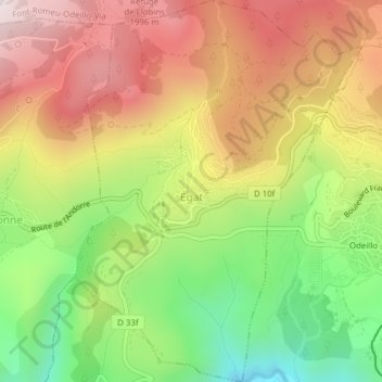
Name: Égat topographic map, elevation, terrain.
Average elevation: 5,541 ft
Minimum elevation: 4,331 ft
Maximum elevation: 6,713 ft
Make a donation
Gear up for your next adventure:
As an Amazon Associate, this site earns from qualifying purchases at no extra cost to you.
Other topographic maps
Click on a map to view its topography, its elevation and its terrain.
Make a donation
Gear up for your next adventure:
As an Amazon Associate, this site earns from qualifying purchases at no extra cost to you.
L'Ermitage
France > Occitania > Pyrénées-Orientales > Font-Romeu-Odeillo-Via > L'Ermitage
Average elevation: 5,856 ft
Saint-Martin de l'Albère
France > Occitania > Pyrénées-Orientales > L'Albère
Average elevation: 2,244 ft
Make a donation
Gear up for your next adventure:
As an Amazon Associate, this site earns from qualifying purchases at no extra cost to you.
Station de Puyvalador
France > Occitania > Pyrénées-Orientales > Puyvalador
Average elevation: 5,801 ft
Les Escaldes
France > Occitania > Pyrénées-Orientales > Angoustrine-Villeneuve-des-Escaldes
Average elevation: 4,892 ft
Make a donation
Gear up for your next adventure:
As an Amazon Associate, this site earns from qualifying purchases at no extra cost to you.