Geolocate

Égat topographic map

Click on the map to display elevation.

About this map

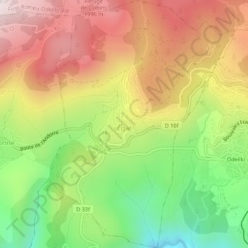
Name: Égat topographic map, elevation, terrain.

Location: Égat, Prades, Pyrénées-Orientales, Occitania, Metropolitan France, 66120, France (42.48660 2.00509 42.51512 2.03413)

Average elevation: 5,541 ft

Minimum elevation: 4,331 ft

Maximum elevation: 6,713 ft

Other topographic maps

Click on a map to view its topography, its elevation and its terrain.

Evol

France > Occitania > Pyrénées-Orientales

Average elevation: 3,461 ft

Perpignan

France > Occitania > Pyrénées-Orientales > Perpignan

Average elevation: 243 ft

Clara

France > Occitania > Pyrénées-Orientales > Clara-Villerach

Average elevation: 2,260 ft

Casteil

France > Occitania > Pyrénées-Orientales > Casteil > Casteil

Average elevation: 3,406 ft

Sorède

France > Occitania > Pyrénées-Orientales > Sorède > Sorède

Average elevation: 400 ft

Sahorle

France > Occitania > Pyrénées-Orientales > Vinça

Average elevation: 1,017 ft

Lavail

France > Occitania > Pyrénées-Orientales > Sorède

Average elevation: 1,293 ft

Thuir d'Évol

France > Occitania > Pyrénées-Orientales > Evol

Average elevation: 3,888 ft

Gear up for your next adventure:

🪶Fire Starter Kit - Reliable fire starter for survival and camping
🧦Merino Wool Socks - Moisture-wicking, blister-preventing socks for long treks
👟Men's Trail Runners - Lightweight footwear for fast-paced exploration and light hiking
📶Vehicle Signal Boosters - Improve reception in rural areas while driving to trailheads
🧭GPS Watch Accessories - Bands and chargers for GPS watches

As an Amazon Associate, this site earns from qualifying purchases at no extra cost to you.