
Thank you for supporting this site ❤️
Make a donation
Make a donation
Gear up for your next adventure:
As an Amazon Associate, this site earns from qualifying purchases at no extra cost to you.
Kalijati Timur topographic map
Click on the map to display elevation.
Thank you for supporting this site ❤️
Make a donation
Make a donation
Gear up for your next adventure:
As an Amazon Associate, this site earns from qualifying purchases at no extra cost to you.
About this map
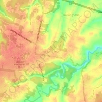
Name: Kalijati Timur topographic map, elevation, terrain.
Location: Kalijati Timur, Subang, West Java, Java, 41271, Indonesia (-6.54438 107.65968 -6.50438 107.69968)
Average elevation: 318 ft
Minimum elevation: 200 ft
Maximum elevation: 377 ft
Thank you for supporting this site ❤️
Make a donation
Make a donation
Gear up for your next adventure:
As an Amazon Associate, this site earns from qualifying purchases at no extra cost to you.
Other topographic maps
Click on a map to view its topography, its elevation and its terrain.
PT.Sinkona Lestari Indoesia Backyard Park
Indonesia > West Java > Subang > Subang
Average elevation: 2,441 ft