Geolocate

Altamont topographic map

Click on the map to display elevation.

About this map

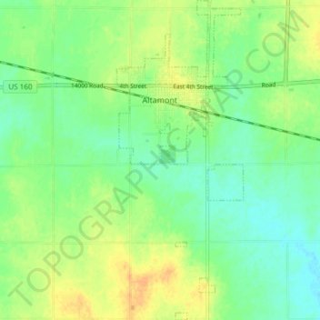
Name: Altamont topographic map, elevation, terrain.

Location: Altamont, Labette County, Kansas, 67330, United States (37.14937 -95.30726 37.20889 -95.27762)

Average elevation: 906 ft

Minimum elevation: 860 ft

Maximum elevation: 961 ft

Labette County trails, hiking, mountain biking, running and outdoor activities

Gear up for your next adventure:

🥇GPS Hiking Watch - Multi‑sport GPS watch with navigation and trail tracking
💧Water Filtration Bottles - Safely drink from streams and lakes while exploring
📦Gear Storage Bags - Organize and protect outdoor equipment
🌡️Portable Weather Meter - Track weather conditions on the trail
🧭Hiking Compass - Precision compass for reliable navigation in the wilderness

As an Amazon Associate, this site earns from qualifying purchases at no extra cost to you.