
Thank you for supporting this site ❤️
Make a donation
Make a donation
Gear up for your next adventure:
As an Amazon Associate, this site earns from qualifying purchases at no extra cost to you.
Terre-de-Haut topographic map
Click on the map to display elevation.
Thank you for supporting this site ❤️
Make a donation
Make a donation
Gear up for your next adventure:
As an Amazon Associate, this site earns from qualifying purchases at no extra cost to you.
About this map
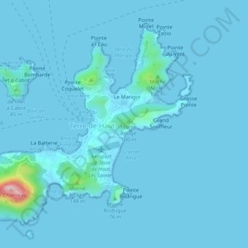
Name: Terre-de-Haut topographic map, elevation, terrain.
Location: Terre-de-Haut, Basse-Terre, Guadalupe, 97137, Francia (15.85252 -61.60673 15.88410 -61.56643)
Average elevation: 36 ft
Minimum elevation: -3 ft
Maximum elevation: 912 ft
Thank you for supporting this site ❤️
Make a donation
Make a donation
Gear up for your next adventure:
As an Amazon Associate, this site earns from qualifying purchases at no extra cost to you.