
Thank you for supporting this site ❤️
Make a donation
Make a donation
Gear up for your next adventure:
As an Amazon Associate, this site earns from qualifying purchases at no extra cost to you.
Vadillos topographic map
Click on the map to display elevation.
Thank you for supporting this site ❤️
Make a donation
Make a donation
Gear up for your next adventure:
As an Amazon Associate, this site earns from qualifying purchases at no extra cost to you.
About this map
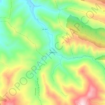
Name: Vadillos topographic map, elevation, terrain.
Location: Vadillos, San Román de Cameros, La Rioja, 26133, España (42.17459 -2.46882 42.21459 -2.42882)
Average elevation: 3,488 ft
Minimum elevation: 2,844 ft
Maximum elevation: 4,344 ft
Thank you for supporting this site ❤️
Make a donation
Make a donation
Gear up for your next adventure:
As an Amazon Associate, this site earns from qualifying purchases at no extra cost to you.