Geolocate

Moyobamba topographic map

Click on the map to display elevation.

About this map

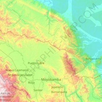
Name: Moyobamba topographic map, elevation, terrain.

Location: Moyobamba, Province of Moyobamba, San Martín, 22001, Peru (-6.11278 -77.74483 -5.40647 -76.74544)

Average elevation: 3,071 ft

Minimum elevation: 486 ft

Maximum elevation: 11,752 ft

Other topographic maps

Click on a map to view its topography, its elevation and its terrain.

Morro de Calzada

Peru > San Martín > Calzada > Calzada

Average elevation: 3,153 ft

Rey del Valle

Peru > San Martín > Alonso de Alvarado

Average elevation: 3,927 ft

Guantanamo

Peru > San Martín

Average elevation: 1,834 ft

San Andrés

Peru > San Martín > Jepelacio

Average elevation: 4,183 ft

Gear up for your next adventure:

🧭Compass with Lanyard - Easy‑carry compass for navigation
🧣Merino Neck Gaiters - Multi-functional headwear for wind and sun protection
🎒Day Hiking Backpack - Lightweight backpack perfect for day trips and outdoor adventures
🛌Ultralight Sleeping Bags - Compact down bags for cold nights in the wilderness
😴Insulated Sleeping Pads - Compact and warm pads for high-elevation camping

As an Amazon Associate, this site earns from qualifying purchases at no extra cost to you.