Geolocate

Elwood topographic map

Click on the map to display elevation.

About this map
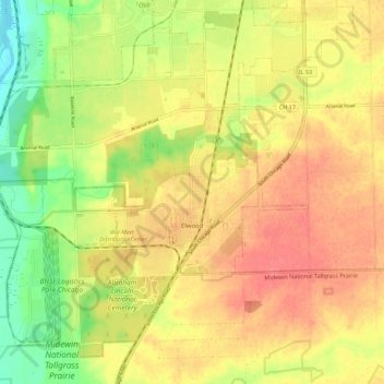
Name: Elwood topographic map, elevation, terrain.

Location: Elwood, Will County, Illinois, United States (41.37507 -88.18990 41.44720 -88.07778)

Average elevation: 620 ft

Minimum elevation: 502 ft

Maximum elevation: 702 ft

Will County trails, hiking, mountain biking, running and outdoor activities

Other topographic maps

Click on a map to view its topography, its elevation and its terrain.

Drummond

United States > Illinois > Will County

Average elevation: 548 ft

Marley

United States > Illinois > Will County

Average elevation: 702 ft

Welco Corners

United States > Illinois > Will County > Bolingbrook

Average elevation: 719 ft

Puddle Pond

United States > Illinois > Will County > Plainfield

Average elevation: 614 ft

Arbury Hills

United States > Illinois > Will County

Average elevation: 709 ft

Gear up for your next adventure:

📌Outdoor GPS Map App - Apps and devices for digital topographic navigation
📦Dry Bags Set - Waterproof storage for electronics and clothes
🪵Folding Camp Saw - Compact saw for wood and campsite work
⛺Backpacking Tents - Weight-optimized shelters for multi-day topographic surveys
🧤Tactile Hiking Gloves - Keep hands warm while operating GPS and smartphone screens

As an Amazon Associate, this site earns from qualifying purchases at no extra cost to you.