Geolocate

Novis topographic map

Click on the map to display elevation.

About this map

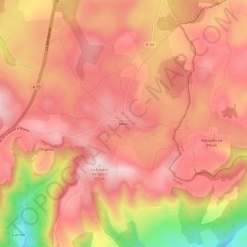
Name: Novis topographic map, elevation, terrain.

Location: Novis, Sévérac-le-Château, Sévérac d'Aveyron, Rodez, Aveyron, Occitania, Metropolitan France, 12150, France (44.24934 3.08993 44.28934 3.12993)

Average elevation: 2,782 ft

Minimum elevation: 2,021 ft

Maximum elevation: 3,114 ft

Gear up for your next adventure:

🥩Freeze-Dried Meals - Nutritious and lightweight food for remote expeditions
🪄Magnetic Compass - Accurate compass for navigation
🪶Paracord Bracelet - Survival bracelet with built‑in tools
🔦LED Headlamp - Bright and durable LED headlamp for night navigation
🧣Hiking Neck Gaiter - Multi‑use neck protection for outdoor weather

As an Amazon Associate, this site earns from qualifying purchases at no extra cost to you.