
Make a donation
Gear up for your next adventure:
As an Amazon Associate, this site earns from qualifying purchases at no extra cost to you.
Canmore topographic map
Click on the map to display elevation.
Make a donation
Gear up for your next adventure:
As an Amazon Associate, this site earns from qualifying purchases at no extra cost to you.
Canmore
Elevation Place opened in April 2013 as Canmore's new recreation facility. Construction of the facility began in 2012 to replace the Canmore Recreation Centre (the community's old facility). The facility offers an 8-lane 25m lap pool, a world class climbing wall developed by Walltopia, two cardio rooms, a strength room, and a host of fitness programs. Elevation Place also houses the community's library and a local art gallery.
Make a donation
Gear up for your next adventure:
As an Amazon Associate, this site earns from qualifying purchases at no extra cost to you.
About this map
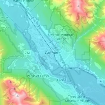
Name: Canmore topographic map, elevation, terrain.
Location: Canmore, Town of Canmore, Alberta, T1W 2H4, Canada (51.04669 -115.38811 51.12669 -115.30811)
Average elevation: 5,135 ft
Minimum elevation: 4,245 ft
Maximum elevation: 8,878 ft
Make a donation
Gear up for your next adventure:
As an Amazon Associate, this site earns from qualifying purchases at no extra cost to you.
Other topographic maps
Click on a map to view its topography, its elevation and its terrain.
Bow Valley Wildland Provincial Park
Canada > Alberta > Town of Canmore > Canmore
Average elevation: 6,050 ft
Make a donation
Gear up for your next adventure:
As an Amazon Associate, this site earns from qualifying purchases at no extra cost to you.