
Thank you for supporting this site ❤️
Make a donation
Make a donation
Gear up for your next adventure:
As an Amazon Associate, this site earns from qualifying purchases at no extra cost to you.
Hirschegg-Pack topographic map
Click on the map to display elevation.
Thank you for supporting this site ❤️
Make a donation
Make a donation
Gear up for your next adventure:
As an Amazon Associate, this site earns from qualifying purchases at no extra cost to you.
About this map
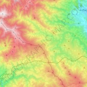
Name: Hirschegg-Pack topographic map, elevation, terrain.
Location: Hirschegg-Pack, Bezirk Voitsberg, Styria, 8584, Austria (46.90950 14.84011 47.08423 15.07571)
Average elevation: 3,638 ft
Minimum elevation: 1,440 ft
Maximum elevation: 6,535 ft
Thank you for supporting this site ❤️
Make a donation
Make a donation
Gear up for your next adventure:
As an Amazon Associate, this site earns from qualifying purchases at no extra cost to you.
Other topographic maps
Click on a map to view its topography, its elevation and its terrain.