
Thank you for supporting this site ❤️
Make a donation
Make a donation
Gear up for your next adventure:
As an Amazon Associate, this site earns from qualifying purchases at no extra cost to you.
Morro do Bruninho topographic map
Click on the map to display elevation.
Thank you for supporting this site ❤️
Make a donation
Make a donation
Gear up for your next adventure:
As an Amazon Associate, this site earns from qualifying purchases at no extra cost to you.
About this map
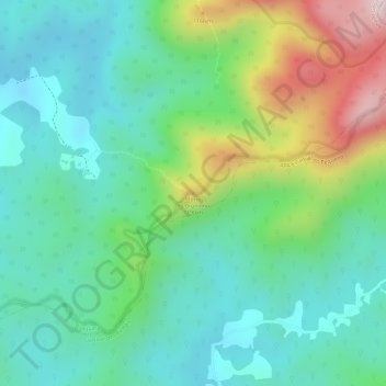
Name: Morro do Bruninho topographic map, elevation, terrain.
Average elevation: 3,333 ft
Minimum elevation: 2,949 ft
Maximum elevation: 4,173 ft
Thank you for supporting this site ❤️
Make a donation
Make a donation
Gear up for your next adventure:
As an Amazon Associate, this site earns from qualifying purchases at no extra cost to you.
Other topographic maps
Click on a map to view its topography, its elevation and its terrain.
Barragem Cayuguava
Brasil > Paraná > Região Metropolitana de Curitiba > Piraquara
Average elevation: 3,005 ft
Floresta ombrófila mista
Brasil > Paraná > Região Metropolitana de Curitiba > Piraquara > Purgatório
Average elevation: 3,077 ft