
Make a donation
Gear up for your next adventure:
As an Amazon Associate, this site earns from qualifying purchases at no extra cost to you.
Marktgemeinde Schruns topographic map
Click on the map to display elevation.
Make a donation
Gear up for your next adventure:
As an Amazon Associate, this site earns from qualifying purchases at no extra cost to you.
Marktgemeinde Schruns
Schruns is a municipality in the Montafon valley (altitude 690 meters), in the Bludenz district of the westernmost Austrian state of Vorarlberg.
Make a donation
Gear up for your next adventure:
As an Amazon Associate, this site earns from qualifying purchases at no extra cost to you.
About this map
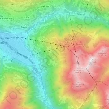
Name: Marktgemeinde Schruns topographic map, elevation, terrain.
Location: Marktgemeinde Schruns, Bezirk Bludenz, Vorarlberg, 6780, Austria (47.04359 9.88647 47.09475 9.98833)
Average elevation: 4,511 ft
Minimum elevation: 2,162 ft
Maximum elevation: 8,150 ft
Make a donation
Gear up for your next adventure:
As an Amazon Associate, this site earns from qualifying purchases at no extra cost to you.
Other topographic maps
Click on a map to view its topography, its elevation and its terrain.
Make a donation
Gear up for your next adventure:
As an Amazon Associate, this site earns from qualifying purchases at no extra cost to you.
Zürs
Austria > Vorarlberg > Bezirk Bludenz
Tourism is the main source of income for the town of Zürs. Due to its high altitude (over 2,000m), the landscape is largely free of forest and therefore offers a clear view of the surrounding Alpine peaks. In addition, there is always plenty of snow in the Arlberg region, providing a picturesque setting for…
Average elevation: 6,742 ft
Make a donation
Gear up for your next adventure:
As an Amazon Associate, this site earns from qualifying purchases at no extra cost to you.
Brandnertal
Austria > Vorarlberg > Bezirk Bludenz > Brand
The Brandnertal is located in the southern part of Vorarlberg, in the far west of Austria. Adjacent to Switzerland, the Principality of Liechtenstein and Germany. In the immediate vicinity of the city of Bludenz starts the Brandnertal. From Bürs the valley rises, via Bürserberg to Brand, which is at an…
Average elevation: 5,157 ft
Zürs
Austria > Vorarlberg > Bezirk Bludenz
Tourism is the main source of income for the town of Zürs. Due to its high altitude (over 2,000m), the landscape is largely free of forest and therefore offers a clear view of the surrounding Alpine peaks. In addition, there is always plenty of snow in the Arlberg region, providing a picturesque setting for…
Average elevation: 6,742 ft
Make a donation
Gear up for your next adventure:
As an Amazon Associate, this site earns from qualifying purchases at no extra cost to you.
Make a donation
Gear up for your next adventure:
As an Amazon Associate, this site earns from qualifying purchases at no extra cost to you.