
Make a donation
Gear up for your next adventure:
As an Amazon Associate, this site earns from qualifying purchases at no extra cost to you.
Rellingen topographic map
Click on the map to display elevation.
Make a donation
Gear up for your next adventure:
As an Amazon Associate, this site earns from qualifying purchases at no extra cost to you.
Rellingen
Es gibt in Rellingen (Stand 2009) rund 5500 sozialversicherungspflichtige Beschäftigungsverhältnisse, wovon etwa 4900 Beschäftigte nach Rellingen einpendeln. Demgegenüber pendeln rund 4200 Einwohner nach Hamburg und andere umliegende Orte aus. Die Gemeinde hat Gewerbesteuereinnahmen in Höhe von 12 bis 15 Mio. Euro jährlich bei einem Gewerbesteuerhebesatz von 320 v.Hd. (Stand 2015).
Make a donation
Gear up for your next adventure:
As an Amazon Associate, this site earns from qualifying purchases at no extra cost to you.
About this map
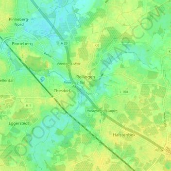
Name: Rellingen topographic map, elevation, terrain.
Average elevation: 36 ft
Minimum elevation: 3 ft
Maximum elevation: 69 ft
Make a donation
Gear up for your next adventure:
As an Amazon Associate, this site earns from qualifying purchases at no extra cost to you.
Other topographic maps
Click on a map to view its topography, its elevation and its terrain.
Liether Kalkgrube
Deutschland > Schleswig-Holstein > Kreis Pinneberg > Klein Nordende
Average elevation: 46 ft
Tävsmoor/Haselauer Moor
Deutschland > Schleswig-Holstein > Kreis Pinneberg > Appen
Average elevation: 30 ft
Make a donation
Gear up for your next adventure:
As an Amazon Associate, this site earns from qualifying purchases at no extra cost to you.
Stadtpark Lieth
Deutschland > Schleswig-Holstein > Kreis Pinneberg > Elmshorn
Average elevation: 26 ft
Sparrieshoop
Deutschland > Schleswig-Holstein > Kreis Pinneberg > Klein Offenseth-Sparrieshoop
Average elevation: 26 ft