
Make a donation
Gear up for your next adventure:
As an Amazon Associate, this site earns from qualifying purchases at no extra cost to you.
Luzaide topographic map
Click on the map to display elevation.
Make a donation
Gear up for your next adventure:
As an Amazon Associate, this site earns from qualifying purchases at no extra cost to you.
About this map
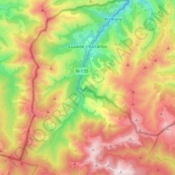
Name: Luzaide topographic map, elevation, terrain.
Location: Luzaide, Pirinioak / Pirineo, Navarre, Espagne (43.01998 -1.35396 43.11871 -1.26358)
Average elevation: 2,881 ft
Minimum elevation: 751 ft
Maximum elevation: 5,112 ft
Make a donation
Gear up for your next adventure:
As an Amazon Associate, this site earns from qualifying purchases at no extra cost to you.
Other topographic maps
Click on a map to view its topography, its elevation and its terrain.
Gouffre de la Pierre-Saint-Martin (Puits Lépineux)
Espagne > Navarre > Pirinioak / Pirineo > Isaba / Izaba
La zone d’infiltration correspond à un karst de montagne dont l'altitude moyenne est de 2 000 mètres environ. L’eau ressort 1 500 mètres plus bas, par de grandes résurgences dans le vallon de Sainte-Engrâce.
Average elevation: 5,604 ft