Geolocate

Munger topographic map

Click on the map to display elevation.

About this map

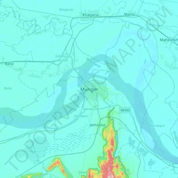
Name: Munger topographic map, elevation, terrain.

Location: Munger, Bihar, India (25.21735 86.31310 25.53735 86.63310)

Average elevation: 144 ft

Minimum elevation: 89 ft

Maximum elevation: 1,165 ft

Gear up for your next adventure:

🧤Hiking Gloves - Protective gloves for rugged trails
🪶Paracord Bracelet - Survival bracelet with built‑in tools
👟Trail Running Shoes - Lightweight shoes for trail runners
🧢Sun Protection Hats - Wide-brimmed and UPF-rated hats for high-altitude sun safety
🥾Hiking Shoes - Durable and comfortable shoes for trail hiking

As an Amazon Associate, this site earns from qualifying purchases at no extra cost to you.