
Make a donation
Gear up for your next adventure:
As an Amazon Associate, this site earns from qualifying purchases at no extra cost to you.
Palikir topographic map
Click on the map to display elevation.
Make a donation
Gear up for your next adventure:
As an Amazon Associate, this site earns from qualifying purchases at no extra cost to you.
Palikir
Palikir is located in the northwestern center of Pohnpei Island (formerly known as Ponape). Geologically the island terrain consists of high mountains to low coral atolls. It is the largest, highest, wettest and most scenic island of the Federated States of Micronesia. Palikir is 8 kilometers (5 miles) southwest of Kolonia, which is Pohnpei's largest town and state capital of Pohnpei State. Underwater reefs are found all round the coastal region of the island. 9 kilometers (6 miles) to the southeast, Mount Nanlaud is the highest point of the Federated States of Micronesia and of Pohnpei at 2,566 feet (782 m) as indicated on the definitive USGS 1:25,000 scale topographic survey. Palikir is surrounded by heavily wooded forest.
Make a donation
Gear up for your next adventure:
As an Amazon Associate, this site earns from qualifying purchases at no extra cost to you.
About this map
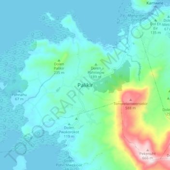
Name: Palikir topographic map, elevation, terrain.
Average elevation: 387 ft
Minimum elevation: 0 ft
Maximum elevation: 2,316 ft
Make a donation
Gear up for your next adventure:
As an Amazon Associate, this site earns from qualifying purchases at no extra cost to you.