Geolocate

Dover topographic map

Click on the map to display elevation.

About this map

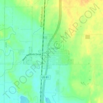
Name: Dover topographic map, elevation, terrain.

Location: Dover, Kingfisher County, Oklahoma, 73734, United States (35.97719 -97.91959 35.98634 -97.90482)

Average elevation: 1,056 ft

Minimum elevation: 1,014 ft

Maximum elevation: 1,102 ft

Kingfisher County trails, hiking, mountain biking, running and outdoor activities

Other topographic maps

Click on a map to view its topography, its elevation and its terrain.

Omega

United States > Oklahoma > Kingfisher County

Average elevation: 1,204 ft

Gear up for your next adventure:

🦶Hiking Gaiters - Keep debris and water out of your boots
🧭Map Reading Tools - Tools and kits for map navigation
🧭Outdoor Navigation Book - Learn advanced navigation skills
📚Navigation Handbooks - Master the art of reading topographic maps and using a compass
📖Nature Tracking Books - Learn to track wildlife and terrain

As an Amazon Associate, this site earns from qualifying purchases at no extra cost to you.