Geolocate

Omega topographic map

Interactive map

Click on the map to display elevation.

About this map

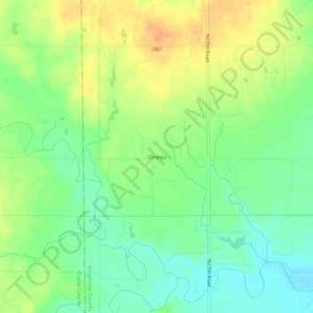
Name: Omega topographic map, elevation, terrain.

Location: Omega, Kingfisher County, Oklahoma, 73764, United States (35.85032 -98.21784 35.89032 -98.17784)

Average elevation: 1,204 ft

Minimum elevation: 1,145 ft

Maximum elevation: 1,266 ft

Other topographic maps

Click on a map to view its topography, its elevation and its terrain.

Kingfisher

United States > Oklahoma > Kingfisher County

Kingfisher, Kingfisher County, Oklahoma, 73750, United States

Average elevation: 1,079 ft

Dover

United States > Oklahoma > Kingfisher County

Dover, Kingfisher County, Oklahoma, 73734, United States

Average elevation: 1,056 ft

Okarche

United States > Oklahoma > Kingfisher County

Okarche, Kingfisher County, Oklahoma, United States

Average elevation: 1,227 ft

Cashion

United States > Oklahoma > Kingfisher County

Cashion, Kingfisher County, Oklahoma, 73016, United States

Average elevation: 1,112 ft

Loyal

United States > Oklahoma > Kingfisher County

Loyal, Kingfisher County, Oklahoma, United States

Average elevation: 1,129 ft