
Thank you for supporting this site ❤️
Make a donation
Make a donation
Gear up for your next adventure:
As an Amazon Associate, this site earns from qualifying purchases at no extra cost to you.
Maresana topographic map
Click on the map to display elevation.
Thank you for supporting this site ❤️
Make a donation
Make a donation
Gear up for your next adventure:
As an Amazon Associate, this site earns from qualifying purchases at no extra cost to you.
About this map
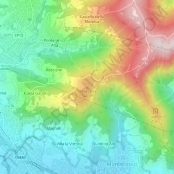
Name: Maresana topographic map, elevation, terrain.
Location: Maresana, Ponteranica, Bergamo, Lombardia, 24010, Italia (45.73051 9.67526 45.73061 9.67536)
Average elevation: 1,417 ft
Minimum elevation: 909 ft
Maximum elevation: 2,306 ft
Thank you for supporting this site ❤️
Make a donation
Make a donation
Gear up for your next adventure:
As an Amazon Associate, this site earns from qualifying purchases at no extra cost to you.