
Thank you for supporting this site ❤️
Make a donation
Make a donation
Gear up for your next adventure:
As an Amazon Associate, this site earns from qualifying purchases at no extra cost to you.
Laundos topographic map
Click on the map to display elevation.
Thank you for supporting this site ❤️
Make a donation
Make a donation
Gear up for your next adventure:
As an Amazon Associate, this site earns from qualifying purchases at no extra cost to you.
About this map
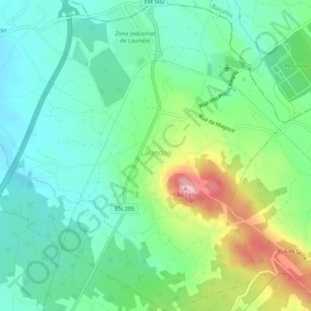
Name: Laundos topographic map, elevation, terrain.
Location: Laundos, Póvoa de Varzim, Porto, Portugal (41.42156 -8.74456 41.45552 -8.70076)
Average elevation: 236 ft
Minimum elevation: 69 ft
Maximum elevation: 617 ft
Thank you for supporting this site ❤️
Make a donation
Make a donation
Gear up for your next adventure:
As an Amazon Associate, this site earns from qualifying purchases at no extra cost to you.
Other topographic maps
Click on a map to view its topography, its elevation and its terrain.
Thank you for supporting this site ❤️
Make a donation
Make a donation
Gear up for your next adventure:
As an Amazon Associate, this site earns from qualifying purchases at no extra cost to you.
Lago do Parque da Cidade Póvoa de Varzim
Portugal > Porto > Póvoa de Varzim > Amorim
Average elevation: 79 ft