
Make a donation
Gear up for your next adventure:
As an Amazon Associate, this site earns from qualifying purchases at no extra cost to you.
Jericho topographic map
Click on the map to display elevation.
Make a donation
Gear up for your next adventure:
As an Amazon Associate, this site earns from qualifying purchases at no extra cost to you.
About this map
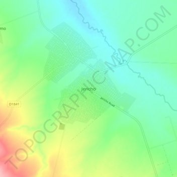
Name: Jericho topographic map, elevation, terrain.
Average elevation: 3,432 ft
Minimum elevation: 3,310 ft
Maximum elevation: 3,714 ft
Make a donation
Gear up for your next adventure:
As an Amazon Associate, this site earns from qualifying purchases at no extra cost to you.
Other topographic maps
Click on a map to view its topography, its elevation and its terrain.
Hartbeespoort Dam
South Africa > North West > Bojanala Platinum District Municipality > Madibeng Local Municipality > Kosmos
Average elevation: 4,114 ft
Pienaars River
South Africa > North West > Bojanala Platinum District Municipality > Madibeng Local Municipality
Average elevation: 3,386 ft
Rooikoppies Dam
South Africa > North West > Bojanala Platinum District Municipality > Madibeng Local Municipality
Average elevation: 3,435 ft
Ukutula Lodge & Lion Park
South Africa > North West > Bojanala Platinum District Municipality > Madibeng Local Municipality
Average elevation: 3,560 ft
Make a donation
Gear up for your next adventure:
As an Amazon Associate, this site earns from qualifying purchases at no extra cost to you.
Rooikoppies Dam
South Africa > North West > Bojanala Platinum District Municipality > Madibeng Local Municipality
Average elevation: 3,435 ft
Madibeng Ward 14
South Africa > North West > Bojanala Platinum District Municipality > Madibeng Local Municipality
Average elevation: 3,501 ft