Geolocate

Marshall topographic map

Click on the map to display elevation.

About this map

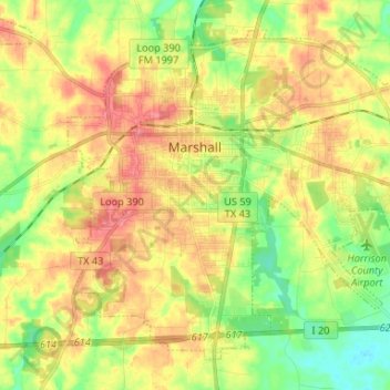
Name: Marshall topographic map, elevation, terrain.

Location: Marshall, Harrison County, Texas, United States (32.48429 -94.40909 32.57813 -94.27748)

Average elevation: 367 ft

Minimum elevation: 253 ft

Maximum elevation: 479 ft

Harrison County trails, hiking, mountain biking, running and outdoor activities

Other topographic maps

Click on a map to view its topography, its elevation and its terrain.

Elysian Fields

United States > Texas > Harrison County

Average elevation: 344 ft

Bel Air

United States > Texas > Harrison County > Marshall

Average elevation: 394 ft

Jasper Heights

United States > Texas > Harrison County > Marshall

Average elevation: 377 ft

Gear up for your next adventure:

🪶Thermal Camp Blanket - Extra warmth for cold nights
🔭Telescopic Hiking Pole - Adjustable pole for hiking stability
🪵Folding Camp Saw - Compact saw for wood and campsite work
🎒Hydration Pack - Hands‑free water reservoir for long hikes
🔦Powerful Headlamps - Ultra-bright hands-free lighting for night navigation

As an Amazon Associate, this site earns from qualifying purchases at no extra cost to you.