
Make a donation
Gear up for your next adventure:
As an Amazon Associate, this site earns from qualifying purchases at no extra cost to you.
Chuyabamba topographic map
Click on the map to display elevation.
Make a donation
Gear up for your next adventure:
As an Amazon Associate, this site earns from qualifying purchases at no extra cost to you.
About this map
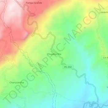
Name: Chuyabamba topographic map, elevation, terrain.
Location: Chuyabamba, Chota, Cajamarca, Perú (-6.53845 -78.72896 -6.49845 -78.68896)
Average elevation: 8,038 ft
Minimum elevation: 7,234 ft
Maximum elevation: 9,245 ft
Make a donation
Gear up for your next adventure:
As an Amazon Associate, this site earns from qualifying purchases at no extra cost to you.
Other topographic maps
Click on a map to view its topography, its elevation and its terrain.
Chota
El relieve del distrito de Chota es un poco accidentado, teniendo en cuenta las altitudes que comprenden los pisos ecológicos (Regiones Naturales), su territorio corresponde a la yunga fluvial, sin embargo, por las características que presenta su floresta, su clima, sus plantas y animales, se considera…
Average elevation: 9,646 ft