
Wespelaar topographic map
Interactive map
Click on the map to display elevation.
About this map
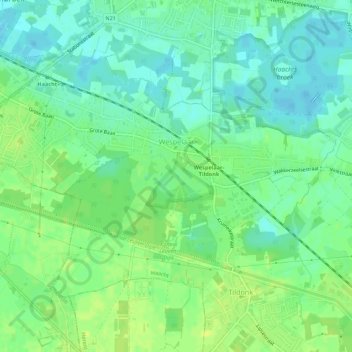
Name: Wespelaar topographic map, elevation, terrain.
Location: Wespelaar, Haacht, Leuven, Vlaams-Brabant, Vlaanderen, België (50.94463 4.60382 50.96834 4.65848)
Average elevation: 36 ft
Minimum elevation: 10 ft
Maximum elevation: 62 ft
Other topographic maps
Click on a map to view its topography, its elevation and its terrain.
Tildonk
België > Vlaams-Brabant > Leuven > Haacht
Tildonk, Haacht, Leuven, Vlaams-Brabant, België
Average elevation: 46 ft
Wakkerzeel
België > Vlaams-Brabant > Leuven > Haacht
Wakkerzeel, Haacht, Leuven, Vlaams-Brabant, België
Average elevation: 33 ft