
Thank you for supporting this site ❤️
Make a donation
Make a donation
Gear up for your next adventure:
As an Amazon Associate, this site earns from qualifying purchases at no extra cost to you.
Campoforogna topographic map
Click on the map to display elevation.
Thank you for supporting this site ❤️
Make a donation
Make a donation
Gear up for your next adventure:
As an Amazon Associate, this site earns from qualifying purchases at no extra cost to you.
About this map
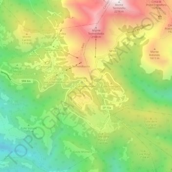
Name: Campoforogna topographic map, elevation, terrain.
Location: Campoforogna, Pian de' Valli, Rieti, Lazio, Italia (42.43372 12.96696 42.47372 13.00696)
Average elevation: 5,135 ft
Minimum elevation: 3,438 ft
Maximum elevation: 7,221 ft
Thank you for supporting this site ❤️
Make a donation
Make a donation
Gear up for your next adventure:
As an Amazon Associate, this site earns from qualifying purchases at no extra cost to you.