
Make a donation
Gear up for your next adventure:
As an Amazon Associate, this site earns from qualifying purchases at no extra cost to you.
Ngantang topographic map
Click on the map to display elevation.
Make a donation
Gear up for your next adventure:
As an Amazon Associate, this site earns from qualifying purchases at no extra cost to you.
About this map
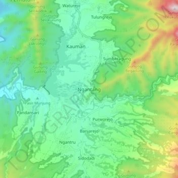
Name: Ngantang topographic map, elevation, terrain.
Average elevation: 2,497 ft
Minimum elevation: 1,535 ft
Maximum elevation: 5,059 ft
Make a donation
Gear up for your next adventure:
As an Amazon Associate, this site earns from qualifying purchases at no extra cost to you.
Other topographic maps
Click on a map to view its topography, its elevation and its terrain.
Bromo Tengger Semeru National Park
Indonesia > East Java > Kabupaten Malang
Bromo Tengger Semeru National Park (Indonesian: Taman Nasional Bromo Tengger Semeru; abbreviated as TNBTS) is a national park located in East Java, Indonesia, to the east of Malang and Lumajang, to the south of Pasuruan and Probolinggo, and to the southeast of Surabaya, the capital of East Java. It is the only…
Average elevation: 4,406 ft
Dsn. Blau Ds. Permanu Kec. Pakisaji, Malang
Indonesia > East Java > Kabupaten Malang
Average elevation: 1,568 ft