
Canillo topographic map
Click on the map to display elevation.
Canillo
During the summer, mountain activities such as railroads, hiking and climbing routes are organized in the parish, as well as bike and cycling routes in Grand Valira and Vall d'Incles. In Canillo is located the highest golf course in Europe, located at 2,250 m altitude (7382 feet), created by the British architect Jeremy Pern.
About this map
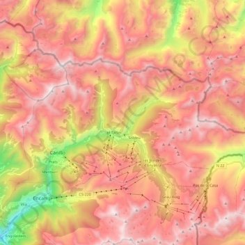
Name: Canillo topographic map, elevation, terrain.
Location: Canillo, AD100, Andorra (42.54356 1.56202 42.63032 1.78666)
Average elevation: 7,267 ft
Minimum elevation: 3,737 ft
Maximum elevation: 9,534 ft
Other topographic maps
Click on a map to view its topography, its elevation and its terrain.