
Ransol topographic map
Click on the map to display elevation.
About this map
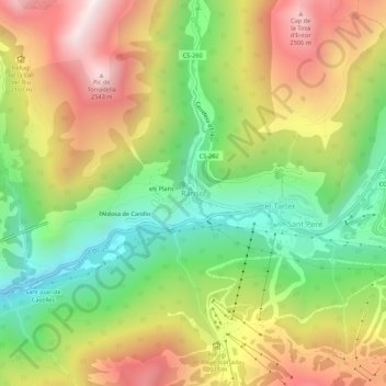
Name: Ransol topographic map, elevation, terrain.
Location: Ransol, Canillo, AD100, Andorra (42.56168 1.61748 42.60168 1.65748)
Average elevation: 6,644 ft
Minimum elevation: 5,095 ft
Maximum elevation: 8,461 ft
Other topographic maps
Click on a map to view its topography, its elevation and its terrain.
Canillo
During the summer, mountain activities such as railroads, hiking and climbing routes are organized in the parish, as well as bike and cycling routes in Grand Valira and Vall d'Incles. In Canillo is located the highest golf course in Europe, located at 2,250 m altitude (7382 feet), created by the British…
Average elevation: 7,267 ft
Encamp
Radio Andorra operated a transmitter at Lake Engolasters in Encamp from 7 August 1939 until 9 April 1981. The antenna still exists at an elevation of 1,600 metres (5,200 ft) (coordinates: 42°31′18″N 1°34′10″E / 42.52167°N 1.56944°E / 42.52167; 1.56944 (Radio Andorra transmitter)).
Average elevation: 6,535 ft