
Thank you for supporting this site ❤️
Make a donation
Make a donation
Gear up for your next adventure:
As an Amazon Associate, this site earns from qualifying purchases at no extra cost to you.
St-Ursanne topographic map
Click on the map to display elevation.
Thank you for supporting this site ❤️
Make a donation
Make a donation
Gear up for your next adventure:
As an Amazon Associate, this site earns from qualifying purchases at no extra cost to you.
St-Ursanne
Située à une altitude de 440 m, Saint-Ursanne est distante de Porrentruy de quelque 15 km et de Delémont de 19 km. La ville fait partie de la commune du Clos-du-Doubs et appartient au district de Porrentruy.
Thank you for supporting this site ❤️
Make a donation
Make a donation
Gear up for your next adventure:
As an Amazon Associate, this site earns from qualifying purchases at no extra cost to you.
About this map
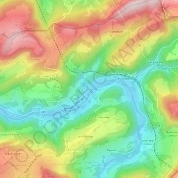
Name: St-Ursanne topographic map, elevation, terrain.
Average elevation: 2,113 ft
Minimum elevation: 1,414 ft
Maximum elevation: 3,012 ft
Thank you for supporting this site ❤️
Make a donation
Make a donation
Gear up for your next adventure:
As an Amazon Associate, this site earns from qualifying purchases at no extra cost to you.