
Make a donation
Gear up for your next adventure:
As an Amazon Associate, this site earns from qualifying purchases at no extra cost to you.
Hohlenweg topographic map
Click on the map to display elevation.
Make a donation
Gear up for your next adventure:
As an Amazon Associate, this site earns from qualifying purchases at no extra cost to you.
Hohlenweg
Im 18. Jahrhundert gehörte der Ort zum Kirchspiel Leichlingen im bergischen Amt Miselohe. Die Topographische Aufnahme der Rheinlande von 1824 und die Preußische Uraufnahme von 1844 verzeichnet den Ort als Hohle Weg bzw. Hohlenweg. Namensgebend war ein Hohlweg entweder an dem alten Communalweg zwischen Leichlingen und Witzhelden (der heutigen Landesstraße) oder einen tief eingeschnittenen Weg vom Ort hinab zu Haus Nesselrath, der im unteren Bereich als Waldweg noch heute erhalten ist.
Make a donation
Gear up for your next adventure:
As an Amazon Associate, this site earns from qualifying purchases at no extra cost to you.
About this map
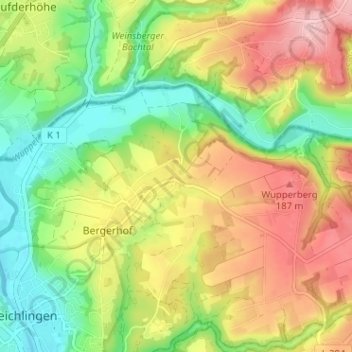
Name: Hohlenweg topographic map, elevation, terrain.
Average elevation: 417 ft
Minimum elevation: 184 ft
Maximum elevation: 689 ft
Make a donation
Gear up for your next adventure:
As an Amazon Associate, this site earns from qualifying purchases at no extra cost to you.