Geolocate

Spaulding topographic map

Click on the map to display elevation.

About this map

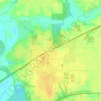
Name: Spaulding topographic map, elevation, terrain.

Location: Spaulding, Sangamon County, Illinois, United States (39.85809 -89.56385 39.87471 -89.52226)

Average elevation: 561 ft

Minimum elevation: 512 ft

Maximum elevation: 600 ft

Sangamon County trails, hiking, mountain biking, running and outdoor activities

Other topographic maps

Click on a map to view its topography, its elevation and its terrain.

Bates

United States > Illinois > Sangamon County

Average elevation: 636 ft

Farmingdale

United States > Illinois > Sangamon County

Average elevation: 591 ft

Gear up for your next adventure:

🔭Stargazing Telescopes - Perfect for camping in low-light pollution areas shown on maps
🧥Waterproof Jacket for Hiking - Breathable and rugged rain jacket for outdoor excursions
🧣Merino Neck Gaiters - Multi-functional headwear for wind and sun protection
🧤Hiking Gloves - Protective gloves for rugged trails
🥇GPS Hiking Watch - Multi‑sport GPS watch with navigation and trail tracking

As an Amazon Associate, this site earns from qualifying purchases at no extra cost to you.